Friday, July 20, 2007

FINAL ALTITUDE: EIGHT READINGS

FINAL ALTITUDE: EIGHT READINGS
Adam Larson / Caustic Logic
The Frustrating Fraud
July 19 2007
updated 8/12


Note1: I’m not precisely certain on ground level altitude at the Pentagon, but it seems to be in the range of about 35-40 feet above mean Sea level (ft msl), so to keep the math simple I’ve rounded it to 40. The discrepancy should be no more than five feet from reality.

Note 2: Possible explanation for pressure altitude errors: airspeed at least has been known to effect this reading, and from what I hear, errors in the range of 100 feet or more are not uncommon. This consideration is relevant for the different pressure altimeter readings in possibilities 2, 3, 5, 6, and 7.

1) Official story/physical evidence/eyewitness reports of impact: these multi-corroborated sources indicate the Pentagon attack plane’s belly was about 5 feet above ground, or about 45 ft msl. A majority of the fuselage impacted just beneath the second floor slab, with left engine and perhaps wingtip in fact hitting objects at ground level. (Source: reality or mind-boggling fakery)

2) Specialist’s Factual Report of Investigation (SFRI): Final alt is unsure – seems near zero but the graph resolution is not high enough to read precisely. In general contours it matches perfectly the more detailed Flight Path Study. (Source: straight from NTSB)

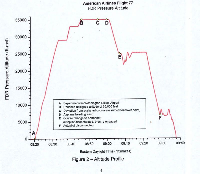
3) Flight Path Study graphing: Still not precisely clear - FDR pressure altitude measured in ft-msl. Lowest graph division is 1,000 feet – Pentagon impact seems to be about zero feet MSL, close to its actual elevation of 40 ft msl. However the Dulles takeoff at about 300 msl, 260 feet higher than the Pentagon, also charts out at what seems zero ft msl, or 300 feet underground? (Source: straight from NTSB - click to enlarge graphic)

4) The PentaCon reading of their eyewitnesses: 100% of their witnesses colse enough to see were convinced of an impact, but various clues indicate a flyover, At least 74 feet above ground level (agl), or 114 ft msl, or the lowest possible level above the roof. The range above that is theoretically limitless, but the lower the altitude, the more likely it could be mistaken by witnesses as an impact with the 73-foot-high building. The higher the altitude, the less sense the flyover theory makes. (Source: Citizen’s Investigative Team)

5) AAl_77.tab, tabular CSV file: final frame altitude of 173 msl, again pressure altitude - sixty feet over the buildin'g roofline. Takeoff alt was at correct elevation for Dulles airport of 300. The CSV file also shows a manual reset of the pressure altimeter at 18,000 feet on descent into the attack, as per FAA regulations, with no apparent effect on recorded pressure alt settings. (Source: NTSB via P49T member Undertow - I need to post my analysis on this soon)

6) The animation, uncorrected, has it 140 feet above ground at the end, somewhat lower at “impact point” if the trends were to continue, but certainly too high to have clipped the poles, hit the generator, or impacted the building. The closeness of this to the CSV indicates the animation was based on pressure altitude – especially with no operative radio altimeter. (source: NTSB via Snowygrouch, then SLOB, Mitch Harrison, etc. – link coming)

7) Read Out 2: An anonymous and irreproducable decoding of the unreadable L3 raw file reveals the nonexistent radio altimeter shows a 270 foot altitude above ground level (agl) at the end. This reading is based on signals bounced from the ground and not subject to pressure alt errors. Radio altimeter is listed in SFRI as inoperative and left blank. Snowygrouch says the reading “had been omitted by the NTSB […] for reasons known only to themselves,” even though it was “precisely the same as the pressure altitude.” It isn’t. (See readings 2, 3, 5, 6) (Source: it’s complicated – the story is here.)

8) John Doe X corrected: When the animation’s final altitude is adjusted to reflect the pressure reset not shown in the animation, the plane is 480 ft msl, 440 ft agl, and 367 ft above the Pentagon’s roof. This is probably too high to have been seen by witnesses at all, and far too high to have been mistaken for an impact. (Source: Animation plus JDX calculations)

Clearly not all of these six altitudes can be correct, though it’s not right to say only one is. Some may corroborate each other, like the animation and CSV, or official and CSV if the alt error was high enough. But to corroborate the PentaCon witness reading, it’d have to be just above the Pentagon roof, and well below that to support the official impact story; there was no high-impact “near-flyover.” It hit low or it didn’t hit.

But this is the only altitude of the eight that also allows the plane to strike the building - matching the (faked?) CCTV video footage, the (fooled?) closest eyewitnesses, the PentaCon’s own (duped?) witnesses, the (planted?) clipped poles and (engineered?) lawn-area damage, the (faked?) 300-foot deep damage to the Pentagon, the (planted?) 757 parts, etc. All these, taken collectively as reality (a leap some are unwilling to take), rule out any altitude higher than the official one. Readings 2, 3, 5, and 6 all could possibly correspond with this, due to the common errors of pressure altimeters, but certainly NTSB data seeming to place the plane well above the roof is problematic.

The higher readings each rule out all of this evidence and each other, and are supported precisely by themselves; another reading with no other backing. There may be more readings yet to come – say, 375 ft msl, or 30,000. That’d be new.

Monday, July 16, 2007

A SLOW ZOOM ON THE FINAL LOOP

A SLOW ZOOM ON THE FINAL LOOP
Adam Larson / Caustic Logic
The Frustrating Fraud
July 16 2007
last updated July 19


Connecting the Dots
The initial flight path of hijacked Flight 77, as published in the days after the attacks, was largely a connect-the-dots approach. With no transponder after the terrorist takeover, and, we were told, “limited primary radar coverage” along the attack route, the return flight was not seen for a half-hour until it entered Washington airspace with its own radar. [1] The dotted line estimations published at this point sowed among the first seeds of suspicion over the attack. Was there a swap out there in the blind spot? As more evidence comes to light, all these paths have proven broadly accurate in that the 757 headed west, turned south over the WV-KY-OH border area, lost transponder, and returned, heading East straight to the Pentagon. Of the three maps above, Newsweek’s is the most accurate. USA Today’s path has a pronounced hump giving it a submarine profile, and Time’s map has the plane swooping north on its way back, crossing its outbound flight path, twisting the loop into an infinity symbol.

The final line of the journey as it passed east of its origin at Dulles, seems from here uneventful. But in these same early days reports surfaced of a tight, controlled, implausible loop over eastern Virginia, thought by many beyond the reported skills of the alleged hijacker Hani Hanjour. Facing the west wall, Flight 77 was said to have turned 270°-360° to hit - the west wall – oddly enough, the side just renovated to withstand bombs and impacts, largely empty, and across the building from the Defense Secretary’s Office. [more on the radar blind spot and the impact location in "From the blind spot to the empty side."]

Few if any eyewitness accounts seem to address the grand loop, since it was simply too big to have been seen by any one person – the first part of it was perhaps too high to attract much attention, but as it approached the Navy Annex and continued to lose altitude, it attracted more witnesses in its last several seconds, by which time it was going straight towards the Pentagon’s west wall. With such published accounts as the early cornerstone of our awareness of the attack, this magical loop remained largely invisible, possibly another government lie.

The overall uncertainty over 77’s approach lead many to accept this flight path as plausible to explain the final loop. It has Flight 77 flying south through DC’s restricted airspace with no White House defensive fire, headed towards Rumsfeld’s office before turning to hit the opposite side of the Pentagon, giving us the 270° turn so often cited. This map is quite wrong, understating the actual degree of turn by 60° and grossly misreading the original heading. [How this old map was arrived at and what’s wrong with it is explained separately in "the "old" 270° loop explained."]

The Radar Record
Among the too-vague early report was this from the ever-unbelievable Vice President Cheney, five days after the attack: "it entered the danger zone and looked like it was headed for the White House [...] Didn't circle it, but was headed on a track into it. [...] It turned away and, we think, flew a circle and came back in and then hit the Pentagon. And that's what the radar track looks like." [2] Five days later CBS News reported “radar shows Flight 77 did a downward spiral, turning almost a complete circle,” after which “the jetliner disappeared from radar at 9:37 and less than a minute later it clipped the tops of street lights and plowed into the Pentagon at 460 mph.” [3]

It was another month before radar specialist Danielle O’Brien, on duty at the Dulles ATC tower on 9/11, told ABC News’ 20/20 “it was an unidentified plane to the southwest of Dulles, moving at a very high rate of speed [...] I had literally a blip and nothing more.” As it headed towards the Pentagon, “it was just a countdown. Ten miles west. Nine miles west […] And it went six, five, four. And I had it in my mouth to say, three, and all of a sudden the plane turned away. In the room, it was almost a sense of relief.” But the turn continued until it was much lower and facing the same direction, after which O’Brien tersely summed up "we lost radar contact with that aircraft [...] and then the Washington National controllers came over our speakers [saying] The Pentagon's been hit.” [4]

O’Brien’s interview, aired in late October 2001, was accompanied by a radar screen graphic with a south loop of near 360 degrees off the east-bound flight as seen on radar screens. Seen briefly by millions, perhaps many thought this arc of dots just a guess or irrelevant, but in fact this same path would prove accurate and come back to bite them in the butt five years later. [Other than the red lettering, this picture is a direct screenshot from the program, viewable here.]

Official Reports: Zooming the Lump
We were only allowed a slow zoom in on what that loop actually looked like in the chain of official reports. Initial NTSB studies were kept behind closed doors, being in the FBI’s jusrisdiction and exempt from FOIA requirements. But the correct loop is there in a map from the 9/11 Commission’s Final Report, released mid-2004. Note its general agreement with early reports, and also the little lump of ink on the south side of the terminal tip – that’s the final loop, unreadable in this bold line on an unnecessarily zoomed back map. This line is apparently taken from the NTSB’s Flight Path Study, made from FDR and radar data in February 2002, classified at the time but available to the commission and cited in the endnotes. The report explained how at "5 miles west-southwest of the Pentagon," Flight 77 "began a 330 degree turn." [5]

That document was finally released via numerous FOIA requests in August 2006 and posted online from numerous angles. Finally we see a zoom in on the mysterious grand loop [see below]. First we see their overall flight path, printed big enough to show a silly little loop at the end [blue box], and also a detail of the loop all on its own page, faded yellow on a pale orange topo map [red box]. This is labeled in the report as “DC area flight path,” so possibly from ATC radar track, while the overall flight path above it is said to be from the matching FDR/radar data. [6]

The Black Box
Additional Flight Data Recorder information further verifies this loop. The Specilaist’s Factual Report of Investigation (SFRI), is an NTSB documented drawing exclusively on the full Black Box readings, also released in the 2006 rush. It has all functioning parameters graphed out for the duration of the flight, spread out over 17 pages; The basics -altitude, airspeed, and magnetic heading - are reproduced on each page. Here is the clearest extraction I've taken of this, edited to show a zoomed-in final minutes reading. All lines and values are accurate according to the bars at right and left. [7]
The story it tells is that at 9:34 Flight 77 began a remarkable thhree-minute turn just short of the Pentagon. The change in magnetic heading is graphed - as it approached DC with a general heading of about 95-100° magnetic –after a slight adjustment to the north and back at 9:31-32, the plane begins its loop at 9:34 – for about three minutes it turns south and then near-full circle to the west, north, and finally settling, at about 9:37, on a northeast heading of 70° magnetic, after completing the 330° turn and descending about 4,000 feet in the process, the last 45 seconds were a straight shot at that heading and a steady descent to roughly zero altitude at 9:37:45.

Here is how to read the headings on a map - apologies for the fruit-flavored style if that offends anyone’s sensibilities. The angle and color tells headingat a given mement, tehe direction the nose is pointing. Magnetic heading, which the FDR works with, are just about 10° higher compared to headings based on geographic north, since the magnetic north pole at that time was about ten degrees west of the true north. Read zero also as 360, due north, green. Here the plane starts out deep blue – due east, roughly 90° from north, 100 mag on the FDR - and its final heading is about 60°. Add ten to get magnetic, and this is what the FDR says – 70°.

The erred NTSB working copy animation, used by Pilots for 9/11 Truth, matches as well the official loop; their “final maneuver” video starts out at 9:34:03, turn just starting, and straightening out from 9:36:45-9:37:15 The onscreen mag heading dial roughly matches the other FDR data, settling on 70 after the loop – but of course the on-screen animation somehow ends up twenty degrees off from that, which is what places it “too far to the left” to have impacted the Pentagon, as the Pilots discovered…

Sources and editing: Coming
[1] Phillips, Don. “Pentagon Crash Highlights a Radar Gap.” Washington Post. November 3, 2001. Page A06. http://www.washingtonpost.com/ac2/wp-dyn?pagename=article&contentId=A32597-2001Nov2¬Found=true
[2] "The Vice President appears on Meet the Press with Tim Russert." Camp David, Maryland. September 16 2001. http://www.whitehouse.gov/vicepresident/news-speeches/speeches/vp20010916.html
[3] "Primary Target - THE PENTAGON." CBS News. September 21 2001. http://www.cbsnews.com/stories/2001/09/11/national/main310721.shtml
[4] "`Get These Planes on the Ground' - Air Traffic Controllers Recall Sept. 11," ABC News, October 24 2001. http://web.archive.org/web/20011024150915/http://abcnews.go.com/sections/2020/2020/2020_011024_atc_feature.html
[5] National Commission on Terrorist Attacks Upon the United States. The 9/11 Commission Report. map: p. 33. Citation of Flight Path Study: Page 459, source 59 for chapter 1. Explanation of the loop on page 9.
[6] FPS
[7] Specialist’s Factual Report of Investigation: Digital Flight Data Recorder . NTSB document number: DCA01MA064 National Transportation Safety Board, Vehicle Records Division. January 31 2002. PDF download link: http://www.ntsb.gov/info/AAL77_fdr.pdf

Friday, July 13, 2007

A PUNCH-OUT FOR CARLSON’S BACKHOE THEORY

A PUNCH-OUT FOR CARLSON’S BACKHOE THEORY
Adam Larson / Caustic Logic
The Frustrating Fraud
July 13 2007


The “punch-out hole” in the C Ring is a true mystery of the Pentagon attack, addressed by an anarchy of theories both in the conspiracy world and in the official story. Official reports fail to clearly explain the near-perfect “wall failure” at the end of the damage path through the building, though they tie it in one way or another to the airliner impact. [location, basics, and official explanations here.]

Some researchers have often seen the possibility that this hole was made on purpose, to some specification for an unknown reason. It’s been wondered if this was related to one of the secondary explosions reported by some. I had wondered on first seeing the hole’s near-perfect form and its size if it wasn’t made by emergency workers [see picture]. It's perfect for human entry, almost a doorway really.

One novel notion to this effect that I feel deserves its own brief post was proposed in 2005 by perennial no-planer clown Jon Carlson.” IT IS CRYSTAL-CLEAR,” he announced at Rense.com, “that this wall opening was made by contruction workers needing to access the inner Pentagon [and] NOT by a landing gear as claimed by Popular Mechanics. “ He presented “the evidence that the WALL OPENING next to the road that runs inside the Pentagon was actually made by a backhoe.” [1]

Carlson noted the symbols that look like upside down anarchy signs, bracketing the spray-painted words “punch out” to the right of the hole. Now, from what I know (a quick internet search) of construction terminology, a “punch list” is “a list of discrepancies that need to be corrected by the contractor,” while a “punch out” is a process of inspecting a site and making a punch-list. [2] In this case, it seems to be a directive to assess the damage inside, or an acknowledgement that the erea had been punched-out. But Carlson gets mixed up and explained “in CONSTRUCTION TERMINOLOGY 'punch-out' refers to making an opening in a wall to access the inside contents of the wall or the inner room.” [3] Oops. Better run a punch-out on Carlson’s wrecked research for any discrepancies to bill him for.

First, let’s look at the Pentagon Renovation press conference from just after the attack that Carlson took as the “FINAL WORD” that this hole was made intentionally. Presenter Terry Mitchell said on September 15:

“this pile here is all Pentagon metal. None of that is aircraft whatsoever. As you can see, they've punched a hole in here. This was punched by the rescue workers to clean it out. You can see this is the -- some of the unrenovated areas where the windows have blown out.” [4]

While it’s not clear which photo(s) he’s really referring to here, Carlson joined this quote with the photo below and for good reason. Note the markings, the flat/straight/square metal scraps (building debris), and the clear view through the gutted building to the (unrenovated) outer E Ring wall north of the impact point. It seems likely, as Carlson decided, that this is the photo referred to.


This must not be the case however – according to Russel Pickering of Pentagonresearch.com anyway, this photo was taken by a FEMA photographer on September 20, nine days after the attack, and five days after Mitchell’s presentation. [5]

Whatever he was really talking about, Mitchell’s “FINAL WORD” is not as useful as Carlson pretends; just before this quote he also said “there was a punch-out. They suspect that this was where a part of the aircraft came through this hole, although I didn't see any evidence of the aircraft down there.” [6] There certainly were parts that seem to be from the plane at the punch-out [link coming], so if he’s talking about the same location, it would appear Mitchell got confused – calling it first a punch-out and then a punch-in. Or perhaps he was showing two different areas. Whatever the case, no other official sources I’ve seen mention a manmade punch-in - they all say the plane did it but can’t agree exactly how.

Carlson then looked at the photo above with its “orange circled 'V's [which] directed the backhoe operator to make the opening within the V's.” He also drew attention to “the orange arrow on left edge of the opening,” just beneath the “no-parking” sign. [7] This he seems to take as the “dig here” mark, but it was clearly painted on after the brick damage.

In fact in the first photos showing the hole there on 9/11, the wall bears no spray-painted “directions” at all to guide the operator, thus nullifying Carlson’s evidence here. This was all done after the fact. The purple backhoe directive to “punch out” the area with its bucket did not appear on the wall until September 14, just in time to be misread by Mitchell the next day. [8] The Vs and the arrow appeared earlier, late on the 12th. As for these symbols, they seem to stand for “victim,” as Pickering explained in his rebuttal to Carlson’s piece:

“[T]he markings on the wall to which Jon refers are international rescue symbols, not backhoe directions. The "V" indicates a victim has been located. If there is a line through the V (an upside down "A") that indicates the victim is deceased. If there is a circle around it, that means the victim has been removed.” [9]

Pickering’s chronological study of hole photos shows that the markings were not there by mid-day Tuesday, but the Vs had been placed, crossed, and circled by photos from that night. [10] Given the devastation inside, I’d find it curious that all bodies in that zone were cleared in less than a day before the morning of 9/13. This could be another clue, but I don't understand the procedures and it's a bit of an aside...

Despite Carlson’s transparently silly analysis, Pickering noted in his rebuttal “the exit hole is very important evidence to indicate a government cover-up because it can't be explained by an aircraft hitting the building.” [11] His worthy analyses of the hole can be found compiled here: http://www.pentagonresearch.com/exit.html Though I cannot agree with his certainty that this is something intentional, I must admit his theory makes at least as much sense as the vague official stories.

Sources:
[1], [3]. [7], [9], [11] Carlson, Jon. “PM Claims Landing Gear Made Pentagon 12 Foot Hole.” With responses from Russell Pickering. March 9 2005. Rense.com. http://www.rense.com/general63/pmm.htm
[2] Home Building Manual. Glossary. http://www.homebuildingmanual.com/Glossary.htm
[4], [6] Lee Evey, Pentagon Renovation Manager, Rear Adm. Craig Quigley, Deputy Asst. Sec. of Def. for Public Affairs, and Terry Mitchell, chief, Audiovisual Division, Office of ASD PA. The Pentagon, Arlington, Virginia. September 15, 2001. 11:00 A.M. EDT http://www.defenselink.mil/transcripts/transcript.aspx?transcriptid=1636
[5], [8], [10] Pickering, Russell. “Exit Hole chronology.” Pentagonresearch.com. http://www.pentagonresearch.com/062.html

Sunday, July 8, 2007

EXTERNAL RESEARCH LINKS {MASTERLIST}

EXTERNAL PENTAGON ATTACK / FRAUD RESEARCH LINKS
Adam Larson / Caustic Logic
The Frustrating Fraud
in assembly... July 27 2007


Please feel free to submit useful links in the comments section below.
------- -------
>> Best General Pro-757 “Truther” Sites:
- Russell Pickering's EXCELLENT Pentagon Research site (Currently down but will return)
- Jean Pierre Desmoulins' "Pentagon 2001 / 9 / 11 : the fraud !"
- 9-11 Research - Pentagon Attack main page
911 Files.info - John Farmer's blog
AAL77.com - John Farmer's invaluable file download page of Pentagon-related media files for fellow researchers.
------- -------
>> Flight 77
- Center for Cooperative Research – Flight 77 timeline.
- Official Passenger List
- Whatreallyhappened: Official hijackers with questions
- Olmstead – no hijackers? (2002 - at least partly debunked by now)
------- -------
Pentagon “honeypot” theorists:
- Jim Hoffman, Oct 2004: "The Pentagon No-757-Crash Theory: Booby Trap for 9/11 Skeptics"
- Oil Empire: "Rumsfeld's "missile" hoax debunked by 9/11 truth activists"
- John Judge's early Fraud warning, Oct. 2002: "Flight of Fantasy: Flight 77 Didn't Hit the Pentagon."
- Mike Rivero: "The "Pod People" And The Plane That Crashed Into the Pentagon"
- New American article: Pentagon 9/11: Getting the Facts Straight
- Joël van der Reijden: "Why the No-757 Crowd is Making an Ass out of Itself"
- Jean-Pierre Desmoulins: "Lies against lies."
- Break For News.com forum: Pentagon - Overview.
- Mark Robinowitz: "Bad Jokes Hidden In Plain Sight"
- Infowars - Video release Designed to Frame The Debate
- Prison Planet: Judicial Watch as honey pot “water carriers”
- Jeff Wells: The Flying Wedge
------- -------
Prime Old-School Fraud Examples:
- Raphael Meyssan: Hunt The Boeing: The 2002 site that started it all...
- Killtown's "Did Flight 77 Really Crash Into the Pentagon?"
- 7th Fire: A Missile, Not Flight 77, hit the Pentagon
- Killtown's Incredibly Useful Flight 77 links page
- Dick Eastman’s “You Decide” Flyover theory
- AmericanPatriotFriends: Where is the Plane, Flight 77?
- 911Lies.org: Missile Damage to Pentagon
------- -------
>> Official Story Explained
- 9/11 Commission, Final Report (pdf)
- Purdue University's 2002 crash simulation
- ASCE's Pentagon Building Performance Report (pdf)
- Pentagon Renovation Program – Phoenix Project
- Arlington County After Action Report – pdf download page
- Flight Path Study (pdf)
- Air traffic control report
------- -------
Debunkers / hitmen for strawmen:
- Screw Loose Change
- Mark Roberts' Loose Change Guide, Pentagon section

- 9/11 Myths: Pentagon page
- Ian Goddard: Pentagon Crash Analysis
------- -------
Physical Evidence: Plane Parts
- Sarah Roberts, Rense.com, 2002: Photo collection of possible 757 parts inside the Pentagon.
- Jim Hoffman/9-11 Research engine page
- Jerry Russell/Richard Stanley – good page on engine
Aerospaceweb: Wheel rim identified - precise style used on Flight 77
------- -------
Video and Analysis:
- Flight 77.info – At the forefront of getting video of the Pentagon attack released
- Henry 62: "Why Don't the Pentagon videos clearly show a plane?"
- John Farmer/BCR Gate cam analysis (9 posts)
- John Farmer/BCR analysis of the Citgo video (32 posts)
- John Farmer/BCR analysis of the Doubletree video (19 posts)
- An analysis of the 9/11 Pentagon videos released by the U.S. Department of Defence on May 16, 2006
- Parody: “Pentagon hit by flying grilled cheese sandwich, video frames show.”
- Michael Moore’s Pentagon camera questions
------- -------
Eyewitnesses/PentaCon
Eric Bart's classic list of eyewitness accounts of the Pentagon crash
The PentaCon/CIT main site
Arabesque - A Critical Review of ‘The PentaCon - Smoking Gun Version’
PentaCon spoof/hit page
------- -------
Flight Data Recorder
JREF Forums: "AA77 FDR Data, Explained"
Flight77 FDR Research: ATS thread I started
NTSB Study of Flight 77's Flight Data Recorder - (PDF download) - released Aug 06
AA77FDR.com - run by Undertow, collecting the known sources said to come from the black box, notably the odd readout 2

Monday, July 2, 2007

NEWS: FRUITS OF A WILD JUNE

THE FRUITS OF A WILD JUNE: NEW STUFF THAT'S UP
Adam Larson / Caustic Logic
The Frustrating Fraud
July 2 2007


Well, things had been slowing down with the site here (and certainly with my other Caustic Logic sites) as I focused energies on two outside fronts. A while back the Center for Cooperative Research, whose seminal Complete 9/11 Timeline I had greatly admired since 2002, approached me to help flesh out some details on the Pentagon attack, which they were still short on. I’m deeply honored to have my first two entries there, dealing with the ASCE’s Pentagon investigation, now up on the 9/11 Investigations Timeline:
ASCE investigation: timeline, players, mandate
Report released, general findings: how the Pentagon responded to the impact of a Boeing 757.

Before and during this time, there was the drama at Above Top Secret.com, which oozed steadily from a the thread I started in late May called ”Pentagon “NTSB” Animation is WRONG!”. Besides the technical considerations by which the animation does not represent the Black Box data, I passed on my doubts over the its authenticity as an “NTSB report” (this will require its own post soon), with often overzealous assistance from another member [Nick7261, to whom I am greatly indebted for making things so interesting]. This triggered Pilots for 911 Truth co-founder John Doe X/Rob Balsamo to pop in with links, insults, a passing threat of lawsuit against Nick and I, and talk of “big-boy” phone interviews and their boundless expertise. In addition he showed me enough new information – corroborating releases of the same animation to different people and with better documentation than what I had previously seen - that I changed course and have since called this an NTSB animation and then set on the path to get a copy myself.

Over the course of June this episode also dragged me into renewed wrangles with The PentaCon producer Craig Ranke/Lyte Trip/Jack Tripper along now with his cohort and Pentagon evidence “expert” Aldo Marquis/Merc. Over the course of two threads, there were some interesting moments, including an invite to a phone discussion with Marquis I seriously considered doing. It’d be wasted breath, I finally decided, about the time Marquis told me I was “dangerous” to the Truth Movement. But as a peace offering I took down my old PentaCon review, to be replaced in time by a series of pieces critiquing the video inside and out.

Now that the first CCR entries are up and the drama at ATS has died down, it’s been a busy few weeks of updating here and July is now a reality, with the site full of new and fascinating things:
NTSB FOIA letter received – no discs included: My first attempt at using the Freedom of Information Act yields instant irony. Damn, that’s what I should’ve called the post…

Litmus test for Rationality? Rebuttal to James Fetzer: The Scholars for 9/11 Truth co-founder and space-beam/TV fakery proponent has laid it down, with Pilots for 911 Truth’s wrong NTSB animation as a final proof that no 757 possibly hit the Pentagon, and people like me are either ignorant of “the evidence,” mentally challenged, or misleading deceitfully. He’s drawn a line in the sand, and I have kicked that sand back in his face.

Michael Moore’s recent 9/11 public questions – his strongest yet towards the inside job paradigm – center on Pentagon video secrecy. I applaud his coming forward, but had to offer an opinion on the issue for what it's worth, and certainly look forward to seeing how he approaches the issue.
Citgo video analysis: I at least started posting things on this, including a graphic chronology of the canopy flash just before impact. More on the way…

On the physical evidence front, recalling Aldo Marquis calling me “dangerous” to the Truth Movement; this was right after I solidly debunked one of the PentaCon’s main “smoking guns” for no 757 impact for all to see. That’s got a post here now too, along with his terse, I sense pained responses to my simple enough case. And just the other day I finally did a basic post on the Punch-out hole, with another on the way.

I’ve also updated various old posts and masterlists, and a new, usable, links section is in the works. There’s no denying the evidence this Summer, folks. Persistent fraudbots got you down? Try the many lines of repellents available here.

COLUMNS 15-17: STILL ATTACHED?

STILL ATTACHED?
BEING A FASCINATING STUDY OF FIRST-FLOOR COLUMNS 15AA-17AA
Adam Larson/Caustic Logic
The Frustrating Fraud
Split-off July 3 2007 from Support Columns masterlist


This photograph by James Ingersoll was used as figure 3.9 in the ASCE’s Pentagon Building Performance Report. It shows exterior support columns 15AA, 16AA, and 17AA, which the report described as “severely distorted but still attached at least at their top ends to the second-floor framing.” [1] This is what I originally saw as well, as have most others. But being just to the immediate left of the main fuselage impact point at column line 14, this should have been the entry point for the right engine and wing root; it stands to reason then they should have been just as removed as the columns to the left of 14.

Despite their distortion, many have taken these columns’ existence at all after the crash as a sign that the no plane the size of a 757 could have entered.For example, Dick Eastman noted these in his piece "You Decide: Fighter Jet? Or 757?" His second proof of a fighter strike, as illustrated by the government graphic at right, is that “the starboard engine would have hit on the first floor at pillar #16. Except that it didn't." He cites their status: "Pillar #15 has been blasted near ground level […] Pillar # 16 is still there, albeit blasted so that it inclines to the right; and pillar #17 is also present and accounted for.” Eastman concluded “clearly there was no starboard engine. An explosion occurring to the left of pillar #15 caused damage to the pillars to the right of it and brought down some outer wall on the first floor wall, but a large turbofan engine of a Boeing 757 never penetrated here. Thus we know that the killer jet was a single-engine aircraft.” [2]

This is classic fraud logic. “there was no 757 because the hole is too small. The “extra damage” is because of explosions to make it look like a bigger 757 hole. But just looking at that hole, you can see it’s too small…" (rinse and repeat).

However, looking at that diagram and noting that everyone agrees that the outermost columns on the left and center of the entry space (10-14AA) were uniformly removed, #15 and 16 indeed should have been nearly vaporized. This never seemed a big enough problem for me to dismiss the 757 hypothesis; I figured the displacement was enough to let an engine pass, but I found it odd that 16 would just "tip over" in straight form rather than being bowed. When I realized the high-right banking angle as well, it became clear this column would have been hit near the top, not the bottom, which makes no sense given the pictured slant of this big, square-sided "damaged column." And I was at least half-aware that the columns the ASCE and I were seeing looked different from each other and from the other pillars we can see, and weren’t quite properly spaced.

In retrospect it was also a bit sloppy of me – and perhaps the ASCE - to be certain these were "support columns" at all. In fact, despite their impressive credentials, no one at ASCE had time to look up close before the collapse, and only so much could be told afterward. in the collapse zone “the team was unable to determine specifically the level and extent of impact damage.” [3] They probably decided on the pillars by looking at these photos – but Jim Hoffman has looked at the same ones and decided “some or all of these objects may in fact be broken portions of the second floor slab that collapsed after the impact,” and came to rest at an angle close enough to vertical to be mistaken for columns. [4] Note also the lowest edge of the 2nd floor façade between 15 and 16 missing a segment of limestone about the size of “column 16.”

Another shot, above, from before the area's blanketing in foam reveals the burning hell a Pentagon doused in jet fuel becomes, as well as better detail on the possible pillars. Here it seems #15 and #17 are just narrow bits of something dangling down nearly to the ground, but these could be battered pillars, reduced to rebar netting. #16 looks most like a solid pillar on first blush, but much burlier than #18 or the other suspects, and I doubt it would look this clean and square if it’d been hit by an airliner at it's "still attached" top end.

Therefore this is actually the weakest candidate for support column and likeliest for second-floor portion –slab, girder, façade, Idon’t know exactly what was there – perhaps something like the chunk missing from the shot above, taken days later and I believe of columns 18, 19 and 20. Perhaps #16 is the sister of the broken slab there, and #17 is the sister of the metal girder beneath it.

Note: “Column 16” appears wider in the original photo, but I noted a light line running down the middle of it, indicating it had a square cross-section, and had somehow rotated about 45 degrees from the camera. When placing it above I “turned it around” by cropping off one side, but then failed to stretch it back out to cancel the perspective. I’ll have to correct this. But anyway, I still say whatever horizontal member this might’ve been, it makes more sense than a column that had been hit by any part of a barreling 757.

A still from the PBPR, a 3-D model by the ASCE. The three red slants here are columns 15-17. Among the worst damaged, these are listed in the Performance Report as “missing, broken, disconnected,” elsewhere described as "without remaining function.” Some were entirely knocked loose but found, some were disconnected but standing, and some totally obliterated, here represented by dots on the floor where they were. These red “columns” appear out of place when all those around and behind it are verified or presumed vanished. I suspect this graphic is incorrect by having the three red pillars shown as anything but dots.

If these three mystery slants are indeed something other than columns 15-17, then we are left with a roughly 90 foot-wide area in which all supports were obliterated on the ground floor, front line - leaving plenty of room for the engine-fuselage-engine penetrating core of a 757, whose deeper but less even damage further in would explain the collapse of everything above that twenty minutes later. While some confusion about this has encouraged speculation and no-757 theories, a little research would show that in either analysis, red is red; missing or in place but non-functional, these columns are no longer functioning support columns because something heavy and fast has traumatized them.

Sources:
[1], [3] Mlakar, Paul et al. “The Pentagon Building Performance Report.” American Society of Civil Engineers. January 2003. PDF version. www.fire.nist.gov/bfrlpubs/build03/PDF/b03017.pdf
[2] Eastman, Dick. "You Decide: Fighter Jet? Or 757? 911 Pentagon Crash Evidence proves False-Flag Frame-up." http://www.bedoper.com/eastman/
[4] Hoffman, Jim. “ERROR: 'Surviving Columns Preclude 757 Crash'” 811 Review.com http://911review.com/errors/pentagon/columns.html